aQRate.
Municipal Asset Management
Turn Municipal Asset Inspections Into Connected Asset Records
Capture structured inspection data, GPS-linked evidence, condition information, and asset history in the field — then turn it into the reports, maps, dashboards, and summaries your municipal teams need.
Offline-first field collection for distributed municipal asset programs — culverts, bridges, roads, and drainage networks.Municipal Assets Are Distributed. Their Data Shouldn’t Be.
A municipal infrastructure team may inspect hundreds or thousands of assets in a season — road segments, bridges, culverts, drainage networks, and facilities spread across the municipality. The inspection itself is rarely the hard part. Keeping the information connected afterward is.
When a culvert inspection lives on paper, its photos sit in a camera folder, and its coordinates land in a separate spreadsheet, the record only exists in pieces. Someone has to reassemble it by hand — and the further the pieces drift apart, the less the inspection is worth.
Multiply that across a season of bridge, culvert, and drainage inspections, and the asset program ends up with field work it can’t fully use.
The same inspection, recorded four times
A two-person crew works a rural road corridor, moving from culvert to culvert. At each structure they photograph the inlet and outlet, note scour and debris, and write the asset ID on a paper tally. GPS coordinates go into a handheld unit, the inspection notes into a spreadsheet a week later, and the photos stay on a phone until someone can match them to the right structure. By budget season, nobody is certain which outlet photo belonged to which asset.
Field inspection
Paper or spreadsheet
Separate photos
Manual data entry
Disconnected asset records
Delayed reporting
When evidence, location, asset identity, and inspection details become disconnected, the field record becomes difficult to use.
One Connected Record From Field Inspection to Asset Management
aQRate gives municipal teams a configurable field-to-report workflow. Watch the general platform overview first, then see how a municipal inspection runs inside it.
01
Capture Structured Inspection Data
Field crews work through a mobile form configured for the asset and inspection workflow: asset ID, asset type, condition rating, measurements, defects, inspection notes, date and time, inspector, GPS location, and photos. Required and structured fields can help standardize what inspectors record across an asset program — and because every municipality configures its own forms, no two asset programs need the same fields.
02
Keep Evidence With the Asset
Photographs and supporting field information stay associated with the asset and inspection record they belong to. On a bridge or culvert inspection, inlet, outlet, barrel, and roadway photographs — plus defect and evidence shots — travel with the structure they document, not as a separate pile of files to be matched to asset records by hand.
03
Work Offline Where Assets Are
Culverts, bridges, and drainage assets are often exactly where cellular coverage is not. aQRate’s mobile apps keep collecting with no signal and synchronize automatically when connectivity returns, so a remote corridor does not pause the inspection program.
04
Connect the Inspection to the Asset Record
The inspection is not just a form submission — it becomes part of the asset’s structured record, so the relationships hold between the asset, each inspection, its condition, the evidence behind it, the finding, the action taken, and the asset’s history.
The Inspection Form Becomes the Asset Record
Instead of collecting information first and organizing it later, the field workflow can be structured around the asset from the moment the inspection begins.
Culvert Inspection
Asset ID*
Location*
Inspection Date*
Location / Watercourse*
Structure Type*
Size / Diameter (mm)*
Condition Rating*
Blockage (%)*
Primary Defects*
Action Required*
Inlet Photo
Outlet Photo
Culvert Inspection
CULV-200
53.29744, -113.8767
2026-08-09T00:00:00.0000000Z
Range Road 213 / Cavanagh Creek
CSP
3000
Good
8
Minor Vegetation
Routine Monitoring
Photo captured
Photo captured
Report ready: Municipal Culvert Assessment
From Field Records to Program-Level Visibility
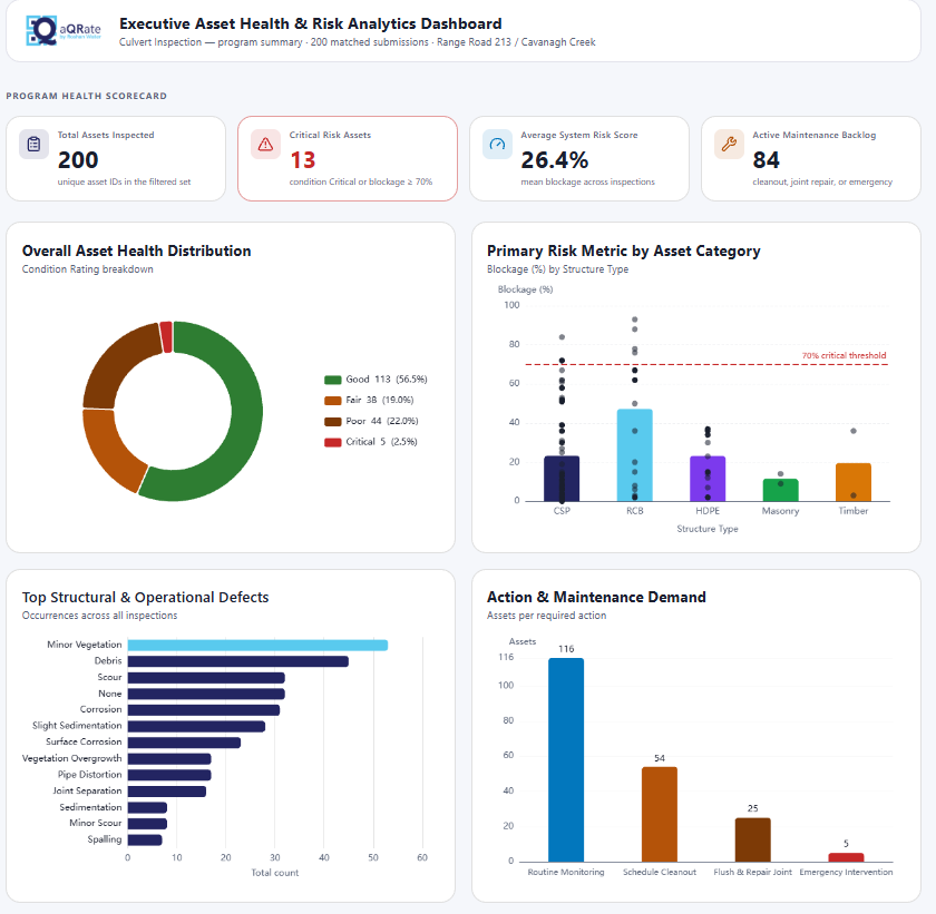
Once structured inspection data is connected to assets, the same underlying records can support different operational views. These screenshots come from the illustrative municipal asset inspection demo workspace.
See the Condition of the Asset Program
KPI-style views can summarize inspection results and asset conditions across the program — which structures have been inspected and what condition categories those inspections recorded. It is the program-level answer that is hard to pull out of a spreadsheet of disconnected inspection rows.
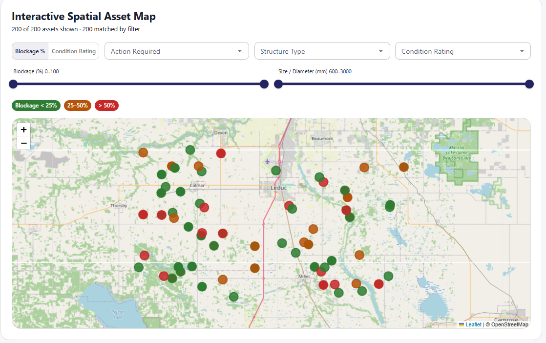
See Where Conditions Occur
A map-based view connects asset condition and rating information with geographic context, so municipal teams move from “Which assets have issues?” to “Where are those assets located?” — the question that drives crew routing and budget conversations.
Culvert Inspection Walkthrough
Follow a full municipal bridge and culvert program from disjointed inspection data to unified asset logs — inspect, capture, connect, review, and report.
Built for Distributed Municipal Asset Programs
aQRate fits municipal teams — and the firms that support them — wherever assets are scattered across the map.
Municipal Public Works Teams
Municipal Asset Managers
Infrastructure & Engineering Departments
Civil Engineering & Inspection Firms Supporting Municipalities
Roads, Bridges & Culvert Programs
Drainage & Stormwater Asset Programs
Start With Your First Inspection Workflow
The standard aQRate setup path — no custom municipal onboarding required.
1
Create your free account
Sign up at portal.aqrate.ca — the ready-made Municipal Asset Management template can pre-load a culvert inspection form, sample records, and dashboards.
2
Download the mobile app
Install the aQRate app for iOS or Android so crews can collect inspections in the field.
3
Build or choose your survey form
Start from the culvert inspection template or configure your own form with sections, photos, GPS capture, and required fields.
4
Collect data in the field
Crews work through assets offline where coverage is thin; records synchronize automatically when the device reconnects.
5
Review submissions
Check field records, evidence photos, and GPS locations in the web portal as inspections sync in.
6
Generate reports and visualizations
Produce assessment reports such as the Municipal Culvert Assessment, and configure dashboards and map views for the program.
Questions Municipal Teams Ask
Can municipal inspections be completed offline?
Can different asset types have different inspection forms?
Can photos and GPS information stay connected to the inspection?
Can we visualize asset condition geographically?
Can aQRate replace our existing municipal asset-management or GIS system?
Can we start with one asset program?
Turn Your Municipal Inspection Workflow Into a Connected Asset Record
Bring your current inspection form, asset log, or field workflow. See how aQRate can connect field observations, evidence, asset information, and decision-ready outputs.